Egg, Stump, Spy

An eyebrow on the forehead of mainland Alaska, the barrier islands of the Beaufort Sea coast stretch across the top of Alaska, separated from the mainland by extensive coastal lagoons. The islands are almost completely barren of vegetation save for a few clumps of Elymus grass and ground-hugging vascular plants. The irony of this dearth is that many of the islands do grow ducks. Pacific common eiders nest in colonies on the barrier islands, often in groups of 100 or more nesting females. It can be difficult to place your foot without stepping on a nest in some of the denser colonies.

IMG_6867

Camp site on Spy Island in the Beaufort Sea. The manmade island Oooguruk, a six-acre gravel drill site,  is visible in the distance. Photo: Sally Andersen

A research trip with US Fish and Wildlife Service to the islands north and west of the busy industrial hub of Deadhorse in July of 2017 to identify nesting eider colonies displayed both the barrenness and fertility of the islands. We found large nesting colonies nearly as soon as we set foot on the islands, but nest after nest after nest had been depredated by an arctic fox. On each new island as we moved west from Deadhorse, we beached our boat, hopeful that we were ahead ahead of the fox. We came upon him on Egg Island sleeping off a stomach full of eider eggs, but it wasn’t until we’d gone over 30 miles from Deadhorse that we found an intact eider colony. While the Arctic fox (or foxes) clearly had an impact on these eiders, recent research shows that they themselves are being outcompeted and even consumed by northward moving red foxes – perhaps these islands were a respite for this hungry individual.

IMG_6842

Eider down strewn about after an arctic fox depredated most of the nests on the barrier island. Photo: Sally Andersen

After so much destruction, it was satisfying to see a successful colony. We banded eighteen birds, one of which was a female who had been previously banded in 2001, the last time the eider colonies had been visited by researchers. She was sitting on a nest, incubating what was perhaps her 10th clutch of eggs.

IMG_6864.JPG

An eider nest on one of the Spy Islands, a group of barrier islands in the Beaufort Sea. Photo: Sally Andersen


Dynamic lagoons of Arctic Alaska: getting a baseline

The National Park Service has produced a video on lagoon fisheries ecology research  in Cape Krusenstern National Monument and Bering Land Bridge National Preserve being led by WCS’s Arctic Beringia program. The video gives a clear and concise view of where and why the work is being conducted and features WCS fisheries ecologists Trevor Haynes and Marguerite Tibbles.

Day 24 IMG_2292

Sounds of the Bering and Beaufort Seas

WCS continues to collect data on the presence of marine mammals and the noise levels they are exposed to in the Northern Bering and Eastern Beaufort seas. As part of this project I went back to Nome, Alaska during the spring of 2017 to work with boat captain Adem Boeckman and his crew on board the F.V. Anchor Point. Our efforts started with a trip to the Bering Strait that took us along King Island’s west coast. Passing the island, we got a good view of Ukivok, a stilted village once the winter home of 200 Iñupiat Alaska Natives, but that now lays abandoned.

Ricardo-Antunes-_DSC1633._-King-Island-village-perched-on-cliffs

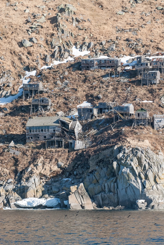
The abandoned village of Ukivok, located on King Island’s west coast.

Leaving King island behind, Adem steered the Anchor Point northwards toward the Bering Strait. This course took us right along the commercial shipping lane proposed by the U.S. Coast Guard as part of the Bering Sea Port Access Route Study. Creation of this shipping lane seeks to minimize environmental and safety risks in this area that is rich in wildlife and of profound importance for indigenous subsistence communities, but lacking in salvage and rescue capabilities. Shipping traffic is predicted to increase in this area, but navigating northwards along the shipping lane we encountered no other vessels (although vessel traffic is generally higher later in the summer). The clear weather provided us with wide views stretching from the Alaskan coast to the East, all the way to the Russian coast to the West.

Ricardo-Antunes_DSC0231_Adem-Boeckman-and-James-Longley-retrieve-sound-recorder-from-the-Bering-Sea

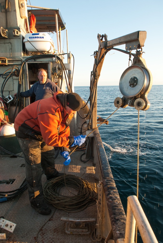
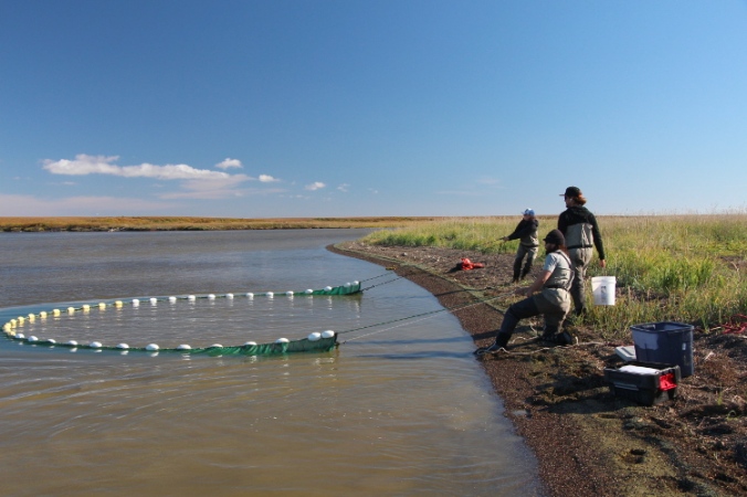
Adem Boeckman and James Longley retrieve a sound recorder from the Bering Sea. Photo Ricardo Antunes.

After several unsuccessful attempts to recover one recorder in Bering Strait, we headed southeast and closer to shore. Everyone on board couldn’t avoid feeling disappointed at the loss of a recorder. There is always a risk of losing equipment that we deploy on the bottom of the sea for months on end, subject to the energetic conditions and shifting substrates of the Bering Sea, and particularly through the notorious storms. More than the equipment itself, it’s the data it contains that is invaluable. These data are essential as we try to better understand the patterns of marine mammal presence, and how levels of underwater noise are changing in this part of world.

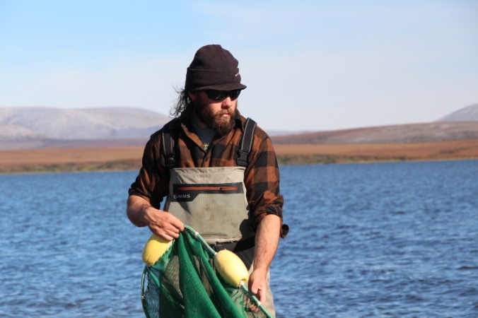
Further along our return trip to Nome our mood recovered when we successfully retrieved the first recorder of the trip. Once again the F.V. Anchor Point’s gear hauling equipment, usually used for crab pots, was invaluable in retrieving the heavy moorings that secure our equipment to the substrate. The size of Adem’s boat allows us to work in ways that wouldn’t be possible using a smaller vessel. Navigating closer to shore, Adem had to slalom the Anchor Point through a field of drift ice while we kept ourselves entertained spotting walruses swimming around the boat and hauled out on the ice. As someone who spends hours and days watching spectrograms and listening carefully to recorded underwater noises, it was gratifying to make closer acquaintance with the originators of some of the sounds!

Ricardo-Antunes_DSC0078_A-walrus-hauled-out-on-an-ice-floe-in-the-Bering-Sea

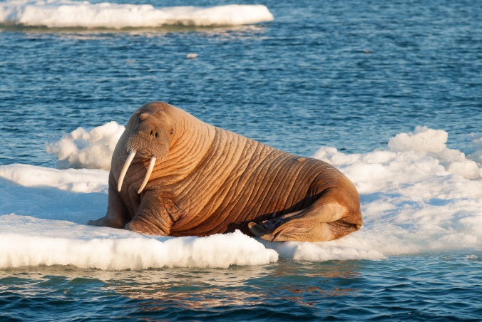
A walrus hauled out on an ice floe in the Bering Sea. Photo: Ricardo Antunes.

With continuing good weather on the horizon we soon followed with another trip to St. Lawrence Island to attempt to recover more recorders. We first approached the island at the northeast cape and then moved along towards the hallowed Punuk Islands. At this point, we were visited by a group of Alaska Natives from Savoonga. They had been hunting off Punuk for several days and were trying to return back to their home village on the north coast. Persistent winds had made the return trip impossible for days and and they were running low on water and other essential goods. This late in the spring hunting season, floes of sea ice are smaller and thinner, and become brackish, not allowing the hunters to extract fresh drinking water from the ice.

RicardoAntunes_DSC0125_Antunes-and-Savoonga-hunters-off-Punik-Is

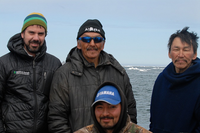
WCS researcher Ricardo Antunes and Savoonga hunters off Punuk Island.

Our encounter with local hunters was a fresh reminder of the dependence that Alaska Natives have on natural resources for their subsistence and cultural identity – a key reason they are also looking to expand their role in the stewardship of their environment. The ongoing changes in this part of the world, caused by climate change and increased shipping, will undoubtedly impact their livelihoods.

Ricardo-Antunes_DSC0011_A-large-male-walrus-swims-among-ice-floes-in-the-Bering-Strait

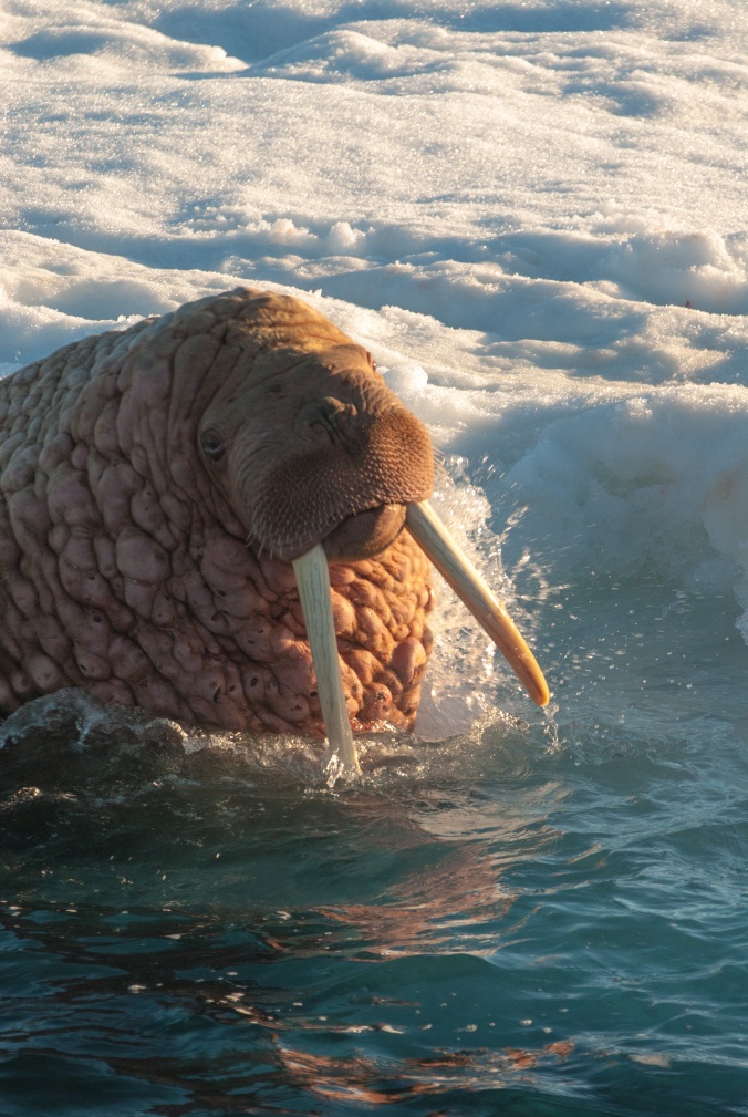
A large male walrus swims among ice floes in the Bering Strait. Photo: Ricardo Antunes.

After sharing water and other goods with our visitors, we proceeded by rounding the island’s Southeast Cape and steamed along the south shores across Powooiliak Bay. At Southwest Cape we recovered two more instruments, one of which had been deployed for two years. Together these two deployments extended over a period of 18 months. We were thrilled to discover that the instruments had worked flawlessly and were loaded with data from this important location that hosts most whaling operations for the Savoonga hunters each spring. Powooiliak Bay is where the St. Lawrence polynya (an area of open water amidst the extensive sea ice cover) develops every year, and where bowhead whales congregate during the winter months. Data from these instruments will help us get a better understanding of when these critically important whales occur in this area.

Ricardo-Antunes_DSC1752_After-two-years-at-the-bottom-of-the-Bering-Sea,-a-sound-recorder-lies-on-deck-after-recovery

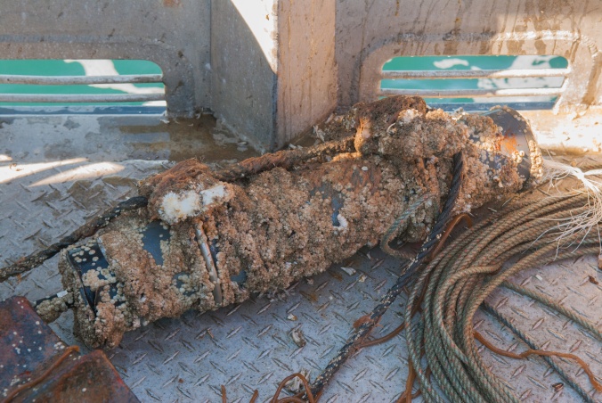
After two years at the bottom of the Bering Sea, a sound recorder lies on deck after recovery. Photo: Ricardo Antunes.

The next stop of the trip was off Gambell, the Alaska Native village at the Northwest Cape of St. Lawrence island – a mere 40 miles from the clearly visible Russian coast! We have been deploying here longer than any of other locations, starting in the summer of 2013 when we deployed our first recorder from a local hunter’s skiff. We hope to build a long-term dataset to better assess any changes caused by climate change.

Ricardo-Antunes_DSC0168_A-pair-of-gray-whales-swims-in-Bering-Sea-waters-off-Gambell

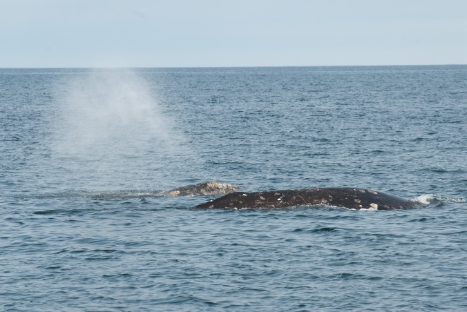
A pair of gray whales swims in Bering Sea waters of Gambell. Photo: Ricardo Antunes.

Gray whales have been a constant presence at Gambell every time that we have been here, both in the fall and the spring trips. The team has become used to seeing individuals and groups of two and three whales foraging around the ship while recovering and deploying our sound recorders. This trip was no exception.

Ricardo-Antunes_DSC0200_A-gray-whale-dives-to-feed-off-St.-Lawrence-Island

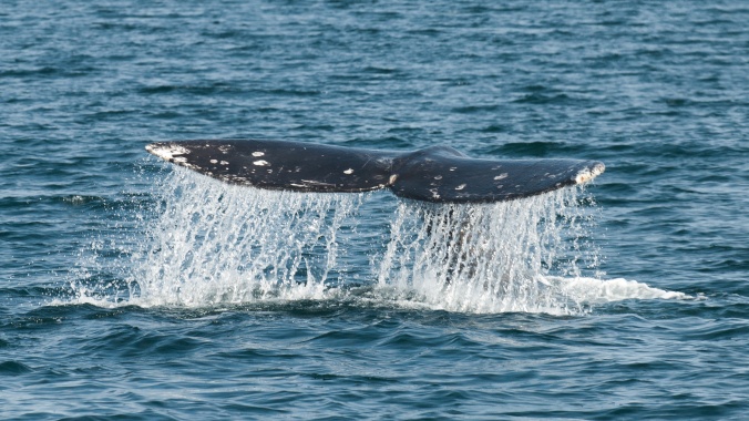
A gray whale dives to feed off of Saint Lawrence Island. Photo: Ricardo Antunes.

We returned to Nome filled with excitement about the new data on board and the revelation that would result from its analysis.

For additional updates about the results, the team, and to hear some of the amazing marine mammal vocalizations, please see summary.wcs.org. Blog written by Ricardo Antunes, WCS, July 2017.


Tagging Buffies Under the Midnight Sun

Buff-breasted sandpipers, or buffies, are an unusual species of shorebird.  Males defend small territories on leks, where they court females through an elaborate wing display. Based on this display or perhaps the spotting on the males wings, females select a mate, copulate, and then leave to nest on their own.

BBSA_Swem

Single-wing display of a male buff-breasted Sandpiper. Photo courtesy of Ted Swem.

Buffies are long-distance migrants that breed in the Arctic and winter in the coastal regions of Argentina, Uruguay, and Paraguay. The species is listed as Near Threatened on the International Union for Conservation of Nature list and is on the U.S. Fish and Wildlife Service’s Birds of Conservation Concern 2016 list. In collaboration with the Migratory Bird Management Division of the U.S. Fish and Wildlife Service, we trapped male buffies in northern Alaska on their leks and attached tiny GPS satellite transmitters to determine where they go after the breeding season. We could only equip males with transmitters as the females are too small to successfully carry the tags. Very little is known about how Buff-breasted Sandpipers use the Arctic coast (e.g., if and where stopover sites occur), although it is thought they remain in the high Arctic for more than a month prior to migrating south through the center of North America. Information on shorebird movements and habitat use along the Arctic Coast is critical to conservation planning and implementation. Baseline data are essential to evaluate how changes in coastal areas are affecting shorebirds, especially because the Arctic coast will continue to change due to sea level rise and greater erosion during the late summer and fall open ice season, and receive lower levels of siltation of river deltas as glaciers recede. The lack of baseline data makes it difficult to assess the potential effects, especially cumulative effects, of industrial development that is changing the Arctic coast.

BBSA

12:30AM. Two biologists hold a mist net between two poles and attempt to drop it over a displaying buff-breasted sandpiper. Capturing birds is difficult unless males are distracted by avian predators flying overhead or females visiting their display sites. Photo credit: Devon Short, WCS.

Only one month after tagging, some of the male buffies have moved east all the way to Banks and Victoria Islands. It will be very exciting to find out where they go next. Our transmitters will hopefully continue to provide GPS-quality location data until mid-August by which time the birds will have reached Texas as they travel toward their South American wintering areas…or points as yet unknown!

BBSA3

1:00 AM. Taking measurements and attaching a satellite transmitter. Photo: Rebecca Bentzen.

This locational data on Buff-breasted Sandpipers is part of a much larger effort to assess shorebird use of coastal sites by many other species. Once all the location data is collected, we can ascertain the relative importance of coastal sites to shorebirds overall, aiding managers in assessing potential issues for current and future developments. We will also learn much more about how this and other species travels across the Arctic and during their southbound travels within North, Central and South America. Where necessary, conservation actions can be initiated at the most important sites rather than guessing where conservation funds can best be spent. Such targeted efforts will lead to increased conservation success.

This project is a partnership between Manomet Inc., the U. S. Fish and Wildlife Service, the Wildlife Conservation Society, the U.S. Geological Survey, and BP Alaska Inc.  Major funding was provided by the National Fish and Wildlife Foundation, and by donors to Manomet.

BBSA4

Map showing the movements of male buff-breasted sandpipers tagged at Prudhoe Bay, Alaska in June 2017.

Written by Rebecca Bentzen, Avian Biologist, Arctic Beringia Program, Wildlife Conservation Society. July 2017.


Brown Bear Surveys in Noatak Preserve and Gates of the Arctic National Parks

As part of the National Park Service’s mission they seek to preserve natural resources for future generations. Monitoring trends in predator populations is vital to recognizing and mitigating any new or persistent threats. In the remote parks of northern Alaska, Wildlife Conservation Society’s Arctic Beringia program is supporting NPS with aerial surveys.

I recently took part in an aerial brown bear survey conducted by the National Park Service and the Alaska Department of Fish and Game in Noatak National Preserve and Gates of the Arctic National Park. I flew in a Supercub airplane (Photo 2) and looked for bears in specific survey units. Most of the survey area was mountainous or open habitat without trees. Bear densities in the northwest arctic are generally lower than in other areas of Alaska and the rate of detection of any given bear is low. To get precise estimates of bear detection and get a more accurate population estimate, we used double sampling photo mark-recapture method. In this method, a pilot-observer team in one plane flies a survey unit and takes locations and photos of bears and shortly thereafter a second pilot-observer team flies the same unit and takes locations and photos of bears. This method allows us to estimate the total population of bears including the bears that neither team observed. This also creates a friendly competition between teams about who saw which bears!

Untitled

A mating pair of brown bears in Gates of the Arctic National Park. Photo Credit: Dylan Schertz

At the end of each day, pilot-observer teams compared photos and locations of the bears they saw to uniquely identify individual bears and bear groups. High quality photos are required so the teams can tell whether or not they saw the same bears. As an observer it was my job not only to collect location, activity, habitat, weather, and group size information about the bears we saw, but also to take photos of the bears. In order to get a quality photo the pilot would set me up for another pass over the bear to get the right angle and lighting. I would wrap the camera strap around my arm, open the side window of the plane, and stick my lens out the window while the pilot turned the plane over the bear.

Untitled1

Returning from a day of surveying, I will be happy to be able to stretch my legs again. Photo Credit: Jesse Cummings

Most people would not enjoy spending 8 hours wedged in the back seat of a small two-seater plane with only one break to get out and stretch and answer any calls of nature!  However, the striking views in the upper Noatak River drainage make us all eager to get back in the aircraft.

Untitled2

Breathtaking views on the flight out to the survey plots. Photo Credit: Dylan Schertz

In addition to the spectacular mountain views, seeing bear cubs fresh out of their den is absolutely amazing. Bears often choose to den on mountain slopes. Shortly after they emerge from their dens bears move out of mountainous areas into lower elevations as the spring and summer progress following the availability of seasonal foods. Females with cubs may remain in mountainous areas longer than other bears to spatially separate themselves and thereby protect their young.

Untitled3

A sow with three cubs of the year in Noatak National Preserve. Photo Credit: Dylan Schertz

Brown bears are a Vital Sign of the National Park Service’s Arctic Network (ARCN) Inventory and Monitoring Program. Brown bears were chosen as a Vital Sign to monitor for several reasons: they are sensitive to habitat fragmentation and habitat loss, human development directly affects their survival, and because they are an “umbrella species.” Umbrella species are species that use a broad range of habitats and require large areas of habitat so their conservation confers protection to other co-occurring species with smaller spatial habitat requirements. The data from this aerial survey and others like it in other ARCN parks will inform biologists about the abundance and distribution of brown bears. This information will allow park biologists and managers to make informed comments about and decisions regarding park management and State and Federal harvest proposals for brown bears. For more information about the Park Service’s work on bears: https://science.nature.nps.gov/im/units/ARCN/vitalsign.cfm?vsid=18

Written by Dylan Schertz, WCS field technician, July 2017

Midnight Wolverine

After coming home from a long day on the job, most people would dread getting a call from the office saying they needed to get back to work immediately, and then for another 6 hours or more. This couldn’t be farther from the truth for us, the Wildlife Conservation Society’s Arctic Beringia wolverine research crew. On March 30th, that call was a satellite-transmitted message telling us that one of our wolverine live traps had closed. What was inside was unknown; what we did know is that we were excited to find out, that night was quickly encroaching, and that the temperatures were already below zero Fahrenheit.

DSC_0026

The moment a pin is pulled from the satellite communicator as the trap closes, prompting us to drop what we are doing and head to the trap. Photo credit: Matt Kynoch.

Despite the timing and dropping temperatures, it was a moment we had been eagerly anticipating for weeks. We’d seen tracks and pictures from remote cameras of an elusive wolverine making somewhat liberal use of the area, but this animal had consistently avoided our traps. After a full day’s work covering around 80 miles on rough and non-existent trails, following wolverine tracks and hauling gear, we ate a quick dinner and excitedly regrouped. Based on tracks we’d seen in the area, the anticipation of finding a wolverine in our trap was high – but we were cognizant to the fact it could be a fox.

Our snow machines made it the 8 miles to the trap in less than an hour, though the journey to a triggered trap can feel like an eternity when you’re bubbling with the anticipation of coming face to face with a new wolverine in a 30”x 5’ wooden box. A quick peek inside the trap revealed a small, surprisingly docile wolverine, more concerned with slobbering over the sweet-smelling carcass we had used as bait, than reacting to our flashlights and prying eyes. Others we’d caught earlier in the season would make their displeasure at capture much better known as they paced and growled in the dust and splinters of attempts to chew their way out of the boxes.

DSC_0111-2

The wolverine trap (left) and Arctic Oven tent where the wolverine is processed in relative warmth to the sub zero temperatures outside. The northern lights in full spate. Photo: Matt Kynoch.

On this night, we had captured a young male, on the small side for male morphology. After a carefully placed anesthetic injection in the rump from a jab stick, essentially a syringe on the end of a pole, the animal could be moved inside our bright yellow Arctic Oven tent. These tents are an arctic camper’s dream, big enough to stand in, and also able to accommodate a fire due to vents in the roof – in our case we heated it with a roaring propane heater. We laid the sedated wolverine on blankets and hot water bottles before measuring him, attaching a satellite collar and an ear tag, and applying antibiotic ointment to a small wound above his left rear leg that looked to have been sustained a couple of days earlier. None of our other captures this year had any sort of injury. There was no indication as what may have been the cause, but it was nevertheless a reminder of the dangers of being a predator in this unforgiving environment. Within an hour our work was done and the small male was placed back in the trap in a blanket, to recover from the immobilization drugs.

DSC_0597

Wolverine and researcher come face to face for the first time. Photo credit: Matt Kynoch.

Most of our days are filled with riding snow machines for long hours, searching for tracks and sign of new wolverines in the foothills of the Brooks Range, or in the many river floodplains that transect the tundra. During these times, with earplugs in, our heads enveloped in full-face helmets, and wrapped up like the Pillsbury Dough Boy in warm bibs and jackets, it’s easy to feel removed from the environment. However, in the couple of hours it took for this young male to be fully recuperated for release, the five of us were treated to more than the gift of this new wolverine. It started with just a few wisps of aurora across a night sky lit only be a thumbnail of a moon and stars. But the aurora grew in intensity to a truly breathtaking display over our temporary wolverine camp – a swirling morass of color that covered the sky at its zenith. At times, the surging colors looked to be within arm’s reach, dancing just above our heads. It was as if the light show over the tundra was just for us and this wolverine. Once released, he loped away in that characteristic 3×4 gait of wolverines, passing out of range of our headlamps, and leaving tracks for us again – but now also breadcrumbs of locations, relayed to us by distant satellites.

DSC_0056

Lead WCS wolverine researcher Tom Glass checking the wolverine prior to handling. Photo credit: Tom Glass.

In the next 24 hours, the animal traveled over 20 miles south into the Brooks Range. He scaled 6,500 foot peaks and precipitous ridges, demonstrating a typical wolverine disregard for topography. The data he provides us will not only paint a picture for male home range movements and activities during the breeding season on Alaska’s North Slope, but also possibly how he relates to other animals that we are monitoring in the area.

DSC_0108

The northern lights tinged with color on our trail home. Photo credit: Matt Kynoch.


Examining wolverine snow holes in light of a changing climate

The alpenglow cast long shadows as we approached the summit. Here in the foothills of the Brooks Range, on top of an isolated peak, we were looking for wolverines. More specifically, we were looking for wolverine snow-holes – places where they had stopped, dug a tunnel into the snow, and rested, sometimes for hours or days.

Wolverine crew.jpg

The WCS wolverine field crew out tracking wolverines, March 2017. Photo credit Matt Kynoch.

The focus of our project is understanding how wolverines use these holes, and what snow characteristics are important to them. In a warming Arctic, this question takes on a heightened significance: will earlier spring snowmelt affect the animal’s ability to raise kits and find appropriate shelter?

IMG_1582

A young female wolverine stands outside the trap that will eventually temporarily trap her. Photo is taken by a Reconyx remote camera.

The 2017 field season is off to a promising start. The young female pictured above is the fourth of our captures so far. On her first visit to the trap, before it was set, she played with the caribou leg behind her for hours, rolling underneath it, tugging, fighting to get it free. Once we did set it, it didn’t take long for her to be tempted in.

On account of a rather round, portly build, we’ve started calling her Po. Her processing went smoothly, and she was up and running again within a few hours. That was three days ago. Since then, she’s traveled 20 km, summited a mountain, and led us to seven different snow-holes. Other animals that we’ve captured appear to make and use snow-holes at a similar, or slightly lower rate – around one per day. Some of the animals are re-using holes, returning to them after a week’s absence, including holes originally created by other wolverines!

IMG_0322

Example of a wolverine snow hole. Wolverines use these holes as resting sites, to raise kits, and possibly to cache food. Photo credit Tom Glass.

Pictured above is where Po took a 10-hour nap shortly after she left the trap. She’s now out on the tundra, wearing a GPS collar that includes an accelerometer and light-logger, instruments that will help us better understand the energetics of her movements, and how she and other wolverines use snow for structure here on the North Slope. Only through such detailed investigation can we fully appreciate what these animals need to thrive in this expansive landscape, and what threats they face in a changing world.

F6 release (2 of 2).jpg

“Po” the female wolverine after being fitted with a satellite collar and released on the North Slope of Alaska. Photo credit Matt Kynoch.

Algal Soup

What do you get when you combine a longer ice-free season in the Arctic with unseasonably warm temperatures? In some cases “algal soup.” And where would one discover algal soup in the Arctic? For our lagoons research crew, it was in the shallow waters of Aukulak Lagoon, just north of Kotzebue on southern coast of Cape Krusenstern National Monument. Aukulak Lagoon is covered by ice for most of the year. During the summer season, ice melts off the lagoon, leaving water that is bounded by the sandy edges of the Chukchi Sea shoreline and highland tundra permafrost to create a shallow, brackish and productive waterbody. With only a short open water season and no agricultural nutrients (which are a common source of these eutrophic events in more populated areas), Aukulak Lagoon might seem like one of the least likely places one might find a massive algal bloom. That is why what we found seemed so remarkable.

day-24-img_1666

Sampling whitefish at the site of an algal bloom in 2016 in Aukulak Lagoon near Kotzebue, Alaska. Photo Jessica L. Bryant

In August, 2016, our lagoons research crew, accompanied by members of the National Parks Service’s videography team went out for what we thought was a typical round of fish sampling. While the sampling itself was routine, the weather over the past week had been anything but normal for autumn in northwestern Alaska. The last few days of August had been unseasonably warm, approaching 70°F, well above the average monthly high of 56°F – a positive heat wave in this area! As part of our commute, we hauled our boats from the Chukchi Sea over the narrow marine berm into the lagoon water that looked like chocolate milk. The culprit, algae, was washing up on shore forming a congealed algal bathtub ring around the entire lagoon. Visibility in the water was essentially zero, and the tiny gelatinous strands of algae could be cupped out of the water held in your hand. However, despite the drastic change in the water, we fished all day and found no obvious effects on the fish we were catching.

day-24-img_1518

Brian Perrault (author) pulling in a whitefish sampling net. Photo Jessica L. Bryant.

Large algal blooms may be relatively undocumented at high latitudes, but are likely on the rise across Arctic lagoons in Alaska. Perhaps connected, productivity of the Arctic Ocean has increased by 47% from 1997-2015. While large algal blooms are common summer events in many freshwater and brackish water ecosystems at lower latitudes, blooms of this scale and at this time of the year in the Arctic raise many questions and also raised the eyebrows of our local partners. Alaska Native communities have been fishing these lagoons for millennia, and local fishermen are truly concerned about the seemingly new phenomenon of large algae blooms. As we later described the event to Cyrus Harris, an experienced subsistence fisherman from Kotzebue, he pulled out his smartphone and showed us pictures from this summer of an algal bloom in another lagoon. He expressed concern about the increased frequency of algal blooms and what it could mean for the subsistence fish that his community depends on.

With a longer ice-free season, algal blooms are likely to become a more common event within the coming years. Of concern to us is that blooms at lower latitudes are often accompanied by large scale fish die offs, often seen in the media as pictures of masses of dead fish floating in the water or washing up on beaches. To our knowledge and that of our local partners, there have been no catastrophic die-offs from algal blooms observed in the Kotzebue region. However, as the Arctic continues to warm, it may only be a matter of time until algal blooms release the large amounts of toxins into lagoons at concentrations that could cause a fish die-off.

algalmat2

Algae growing in the water of Aukulak Lagoon. Photo Stacia Backensto.

Recent research has shown that pinnipeds –seals, sea lions and walruses– in Alaska, most of which feed heavily on fish and shellfish, have high levels of the algal toxins domoic acid and saxitoxin. Given that both seals and fish are critical to local food security, it is no wonder that the blooms of concern to researchers and local residents alike. Alex Whiting, the lead scientist for the Native Village of Kotzebue, points out that there is a general lack of awareness of the issue outside of the local community and marine mammal scientists, noting “It’s concerning when we see the impacts (of algal blooms) in the Great Lakes and California… (but) the local issue will continue to be esoteric until there is a die-off”. Whiting and WCS are working hard to ensure there is more research and monitoring of algal blooms in these lagoons so that we have the information necessary for managers and fishermen to respond to this new phenomenon.

Written by Brian Haggerty Perrault. December 2016.

Caspian Terns Nesting in the Arctic

img_8580

First photo of a Caspian tern chick in Arctic Alaska. This photo was one of two chicks on the island. The breeding pair was first discovered on July 23rd, this photo was taken July 26, 2016 by Kevin Rodriguez.

Arctic coastal lagoons are incredibly important for a diversity of breeding birds. Arctic lagoons are key habitat for feeding, nesting, molting and chick rearing for Pacific, red-throated and yellow-billed loons; waterfowl species such as longtail ducks, white-fronted geese and common eiders; shorebirds such as western and semipalmated sandpipers and black turnstones, and tern species including Arctic and Aleutian Terns. However, there is a new species of bird that is now relying on Arctic Lagoons.

img_8586

Adult Caspian tern at Cape Krusenstern, 2016. Photo by Kevin Rodriguez.

While sampling the physical properties of water at Cape Krusenstern Lagoon in late July, a strange call drew our attention. Up until then, it was an unfamiliar noise in the Arctic; but for the rest of the summer it occasionally punctuated our day as we sampled lagoons as part of a Vital Signs Program for the National Park Service. That noise was the call of a Caspian tern, investigating us as we came close to a small sandy island in the lagoon. We approached the island to find that the terns had two healthy chicks. We were surprised to see breeding Caspian terns, knowing that this was far beyond their known breeding range. We revisited the island to check on the tern chicks through the rest of the season. Monitoring their progress, we were excited to see that the chicks fledged. On regular occasions after the chicks fledged, we saw either one or two chicks flying around the lagoon with their parents.

img_8595

Adult Caspian tern breeding on a small island in Cape Krusenstern Lagoon. Photo by Kevin Rodriguez.

As a consequence, Cape Krusenstern National Monument now hosts the first known breeding Caspian terns in the Arctic (defined here as above the Arctic Circle). The Caspian terns breeding on Krusenstern Lagoon are almost 600 km further north from the previously recorded most northerly nesting location at Neragon Island in the Bering Sea. The breeding pair also represents the first Caspian terns observed breeding in the Chukchi Sea basin. The success of the breeding Caspian terns in the Arctic is likely related to the expanding growing season. Compared to most terns, Caspian terns have a longer incubation period and chicks grow more slowly. Warming in the Arctic has resulted in a dramatically longer ice free season and potential shifts in prey base that have been accompanied by major shifts of seabird species (Gall et al. 2016) and their ecology (Divoky et al. 2015). The ice-free season may only recently be long enough for Caspian terns to complete the long process of breeding. As Caspian terns continue to expand their range northward, we shouldn’t be surprised to find our successful pair being joined by other Caspian terns as they increase their presence in the Arctic.

ternisland

The small island in Cape Krusenstern Lagoon used by a breeding pair of Caspian terns. Photo by Trevor Haynes.

http://www.sciencedirect.com/science/article/pii/S007966111500107X

Divoky, G.J., P.M. Lukacs and M.L. Druckenmiller. 2015. Effects of recent decreases in arctic sea ice on an ice-associated marine bird. Progress in Oceanography 136: 151–161

Gall, A.E., T.C. Morgan, R.H. Day and K.J. Kuletz. 2016. Ecological shift from piscivorous to planktivorous seabirds in the Chukchi Sea, 1975–2012. Polar Biology: 1–18

Written by Trevor Haynes, Wildlife Conservation Society. November 8, 2016.